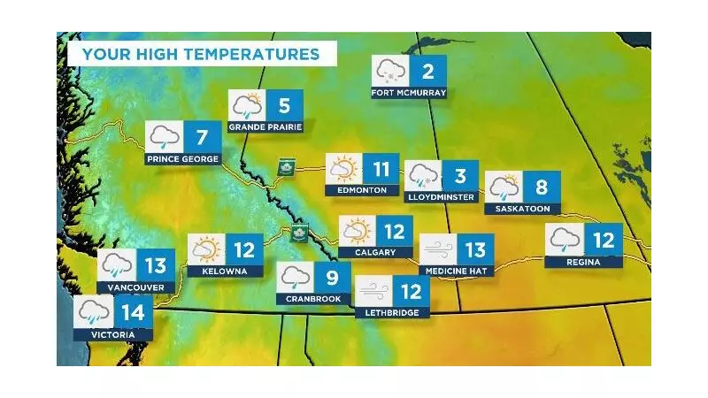
Southern Alberta residents are waking up to a meteorological rollercoaster this Wednesday as a powerful weather system sweeps across the region, bringing a triple threat of strong winds, substantial rainfall, and surprisingly warm temperatures.
A Windy and Wet Welcome
The day began with winds gusting between 50 to 70 km/h throughout southern Alberta, creating challenging conditions for morning commuters and outdoor activities. Environment Canada has been closely monitoring the system, which is delivering widespread rain across the foothills and much of the southern portion of the province.
Temperature Anomaly Turns Heads
In what might feel more like spring than late fall, temperatures are expected to climb into double digits across many southern Alberta communities. This represents a significant departure from seasonal norms and could challenge previous temperature records for this time of year.
Regional Variations and Impacts
The weather system isn't affecting all areas equally. While Calgary experiences the full brunt of windy conditions and rainfall, other regions are seeing different patterns:
- Northern Alberta: Colder temperatures with potential snow flurries
- Mountain Regions: Mixed precipitation and stronger wind gusts
- Eastern Sections: Lighter rainfall but maintaining windy conditions
Looking Ahead: What's Next for Alberta?
Meteorologists suggest this active weather pattern may continue through the week, with another system potentially developing over the weekend. Residents are advised to stay updated with the latest forecasts and prepare for rapidly changing conditions.
The combination of saturated ground and strong winds could lead to localized issues, including minor flooding in poor drainage areas and potential branch debris from trees. Drivers are cautioned to adjust their speed for both reduced visibility and potential hydroplaning conditions.


