Get your umbrellas ready, Southern Ontario! A series of weather systems is lining up to deliver a week of unsettled conditions, marking a significant shift from recent weather patterns.
What's Coming Our Way
Meteorologists are tracking multiple low-pressure systems queuing up to affect the region throughout the coming week. This "parade of storms" promises to bring consistent rainfall and noticeably cooler temperatures that will feel more like early spring than typical late-season weather.
The Weather Timeline
The first system arrived Sunday night, setting the stage for what's to follow. According to CTV News London meteorologist Julie Atchison, "We're looking at a very active pattern with several systems lining up back-to-back."

The forecast shows:
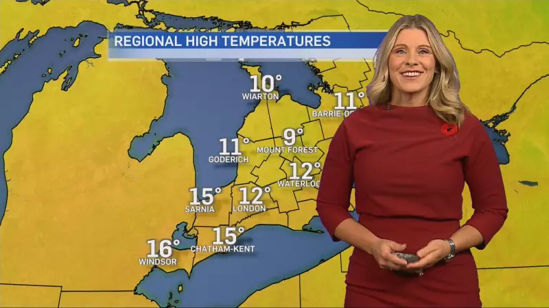
- Monday: Cloudy with showers and a high of 14°C
- Tuesday: Periods of rain continuing with similar temperatures
- Wednesday through Friday: Additional systems maintaining the wet pattern
Temperature Drop Noticeable
While not dramatically cold, the persistent cloud cover and precipitation will keep temperatures several degrees below seasonal norms. The mercury will struggle to reach the mid-teens, creating conditions that might have you reaching for an extra layer.
The silver lining? This pattern represents a return to more typical spring conditions after the unusually warm and dry stretch the region experienced earlier.
Why This Pattern Matters
This extended period of rainfall could significantly impact outdoor activities, agriculture, and local water tables. Gardeners and farmers will welcome the moisture, while commuters should prepare for potentially slower travel conditions.
As Julie Atchison notes, "It's a classic spring pattern that we haven't seen much of this season until now." The consistent precipitation helps replenish groundwater and supports the region's vibrant spring growth.
Stay tuned to CTV News London for continuous weather updates as these systems develop and move through Southern Ontario.