Flood Warnings Issued for Multiple Ontario Regions Including Brantford and Six Nations
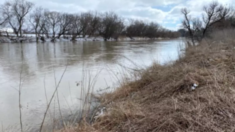
Emergency management officials have issued urgent flood warnings for several municipalities in southwestern Ontario, including Brant County, the City of Brantford, Six Nations of the Grand River, and Haldimand County. The warnings come as water levels continue to rise along the Grand River watershed, posing significant threats to residential areas, agricultural land, and critical infrastructure.
Immediate Threats to Communities
The Grand River Conservation Authority has activated its flood warning system, indicating that current conditions present a substantial risk of flooding. Residents in low-lying areas near the Grand River and its tributaries are advised to take immediate precautions, including securing property, preparing emergency kits, and developing evacuation plans if necessary. Municipal emergency services are on high alert, with sandbagging operations already underway in some vulnerable locations.
Historical context reveals that this region has experienced severe flooding events in the past, most notably during the spring of 2018 when extensive damage occurred. Current weather patterns, including recent precipitation and snowmelt from upstream areas, have created conditions similar to those preceding previous flood disasters.

Specific Areas of Concern
Authorities have identified several specific areas requiring particular attention:
- Brantford's riverfront districts, where the Grand River flows through the city center
- Agricultural lands along the Grand River in Brant County
- Residential areas of Six Nations of the Grand River near the riverbanks
- Low-lying regions of Haldimand County adjacent to the watershed
Emergency officials are coordinating with Indigenous leadership in Six Nations to ensure proper notification and response measures are implemented throughout the territory.
Response and Preparedness Measures
Local municipalities have activated their emergency operations centers and are working in coordination with provincial agencies. The Ministry of Natural Resources and Forestry is providing technical support and monitoring equipment to track water levels in real-time. Residents are encouraged to stay informed through official channels and avoid unnecessary travel near affected waterways.
Environmental factors contributing to the elevated flood risk include saturated ground conditions from earlier precipitation, ongoing snowmelt in the river's headwaters, and forecasted rainfall in the coming days. Climate scientists note that such extreme weather events are becoming more frequent and intense due to changing climate patterns.
Property owners with flood insurance are advised to review their coverage and document current conditions. Those without flood insurance should take extra precautions to protect valuables and important documents. Emergency shelters are being prepared in case evacuation orders become necessary.