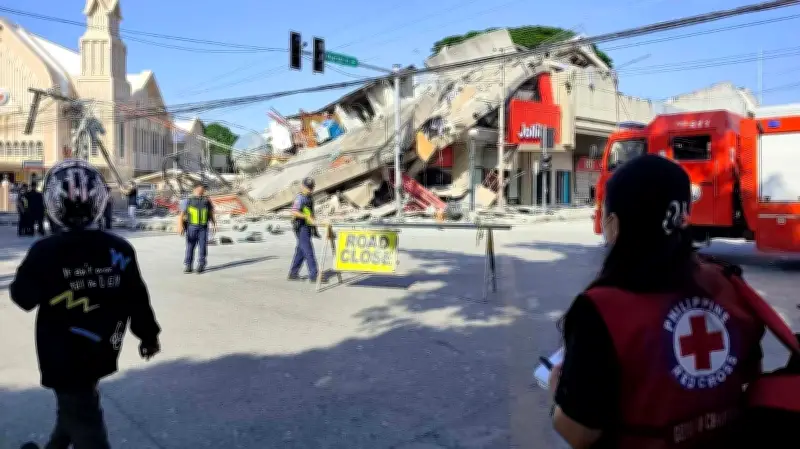
A powerful offshore earthquake with a magnitude of 7.8 struck the southern Philippines on Monday, resulting in at least 19 fatalities and more than 200 injuries. The quake caused buildings to collapse and generated a 1-meter (3-foot) tsunami that impacted nearby coastlines.
Impact on General Santos and Surrounding Areas
In the port city of General Santos, several buildings collapsed, and key infrastructure sustained damage. The city, home to over 700,000 people, serves as a regional hub for the tuna export industry. Tsunami damage was reported in at least one coastal village, with smaller waves recorded in Indonesia, Palau, and as far as southern Japan.
Rod Sosmeña, regional director of the Office of Civil Defense, recounted his experience: "Our pickup truck suddenly jerked and I thought we had a flat tire. The shaking was very strong and people dashed out of houses into the streets." He was traveling in General Santos when the quake struck at 7:37 a.m.

Casualties and Damage Assessment
Office of Civil Defense spokesperson Junie Castillo confirmed that at least 19 people died, primarily due to collapsed buildings and landslides, while thousands of villagers were displaced. In General Santos alone, seven people perished, and several small buildings, including a popular hamburger restaurant, collapsed or were severely damaged.
Other deaths resulted from falling debris, a damaged mosque, and a landslide in the southern provinces of Sarangani, South Cotabato, and Davao Occidental, as well as on Balut Island. Authorities are investigating reports of students trapped in a two-story school that collapsed in General Santos. The national police indicated that at least 12 people remain missing in the city.
Tsunami Waves and Regional Effects
Waves of 1 meter (3 feet) were observed in Sultan Kudarat and Sarangani provinces, with a peak of 1.4 meters (4.6 feet) recorded off Kiamba town in Sarangani. The quake was also felt in Malaysia's Sabah state on Borneo island. An 83-centimeter (2.7-feet) tsunami was measured off Indonesia's Sulawesi island, and 30-centimeter (1-foot) waves were detected in Palau. In Japan, waves up to 20 centimeters (7.8 inches) reached the remote island of Chichijima and the town of Kushimoto.
The Pacific Tsunami Warning Center announced that the tsunami threat had largely passed about five hours after the quake. Philippine officials lifted their tsunami warning by mid-afternoon.
Government Response and Aftershocks
Philippine President Ferdinand Marcos Jr. ordered the cancellation of classes and directed disaster-response agencies to immediately assist affected provinces, stating, "The national government is moving and we will not leave Mindanao behind." The international airport in General Santos was temporarily closed, and 17 domestic flights were canceled.
The earthquake, the strongest to hit the Philippines this year, was centered at sea off Mindanao at a depth of 33 kilometers (20 miles), about 32 kilometers (20 miles) southwest of Maasim town in Sarangani province, according to Teresito Bacolcol, director of the Philippine Institute of Volcanology and Seismology. The U.S. Geological Survey reported a depth of 55 kilometers (34 miles), with aftershocks as strong as magnitude 6.5.
The Philippines, located on the Pacific "Ring of Fire," is frequently affected by earthquakes and volcanic eruptions. The archipelago also experiences about 20 typhoons and tropical storms annually.