Stallion Uranium Launches Expanded Ground Gravity Survey in Saskatchewan's Athabasca Basin
VANCOUVER, British Columbia – Stallion Uranium Corp. (TSX-V: STUD; OTCQB: STLNF; FSE: B76) has announced the mobilization of an expanded high-resolution ground gravity survey on its Coyote Target corridor, located in the Athabasca Basin of northern Saskatchewan, Canada. The current program represents a significant extension of the company's previous survey work, with coverage expanding westward from the original survey area.
Technical Objectives and Exploration Strategy
The expanded survey program has been specifically designed to achieve several critical exploration objectives:
- Identify additional gravity lows associated with interpreted density destruction in basement rocks
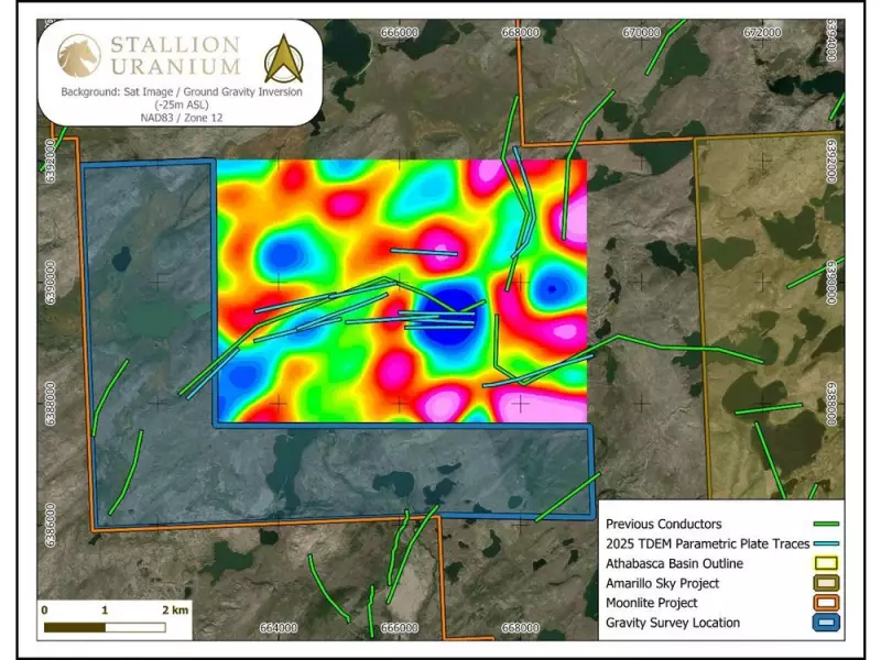
- Refine the geometry and continuity of anomalies identified at the margins of the earlier survey
- Improve understanding of the size, orientation, and continuity of priority anomalies at the Coyote Target
- Focus on gravity lows identified along the edges of the previous survey that remain open and poorly constrained
High-resolution ground gravity surveying has proven particularly effective in the Athabasca Basin for identifying alteration-related density lows, including its successful application in the discovery of NexGen Energy's PCE uranium deposit.

Expert Commentary on the Survey Expansion
Darren Slugoski, Vice President of Exploration for Stallion Uranium, emphasized the strategic importance of the expanded survey: "Extending the ground gravity survey is important not only for refining existing anomalies, but also for identifying additional target areas along the broader Coyote conductive trend. In the Athabasca Basin, multiple uranium deposits are known to occur along the same structural corridor, as demonstrated by the Patterson Lake corridor."
Slugoski further explained that "expanding coverage beyond the original survey boundaries will help us better define the continuity of alteration-related gravity lows and evaluate the potential for multiple uranium systems along the Coyote Trend."
Kyle Patterson, P.Geo., President of Convolutions Geoscience Corp., provided additional technical insight: "Review of the existing gravity inversion suggests that key density lows at Coyote are not fully constrained at the western edge of the current survey coverage. Extending the ground gravity program is a logical next step to better define the geometry and continuity of these features, which may be associated with basement-hosted alteration systems."
Coyote Target Selection and Geological Context
The Coyote Target was selected following a comprehensive technical evaluation that incorporated multiple data sources:
- Historical and recently acquired geological mapping data
- Geochemical analysis results
- Multiple geophysical survey datasets
The target exhibits characteristics consistent with basement-hosted uranium systems in the Athabasca Basin, where hydrothermal alteration commonly results in interpreted density destruction that can be effectively delineated using high-resolution ground gravity surveys.
Program Implementation and Data Integration
The survey program is being conducted by MWH Geo-Surveys Ltd., utilizing ground gravity methods that have proven particularly effective for mapping basement-hosted alteration systems. Survey results will be integrated with existing geological, geochemical, and geophysical datasets to further refine priority drill targets for future exploration phases.
This expanded survey represents a methodical approach to exploration in one of Canada's most significant uranium-producing regions, leveraging proven geophysical techniques to identify potential mineralization systems that could contribute to Canada's position as a global leader in uranium production.