Maxus Mining Inc., a Canadian mineral exploration company trading on the CSE under the symbol MAXM, has announced a significant milestone in the development of its Quarry project located in British Columbia. The company has successfully completed a thorough compilation of all available historical drillhole data for the property, marking a crucial step toward modern resource estimation.
Comprehensive Data Compilation Sets Stage for Advanced Exploration
The recently completed compilation represents a comprehensive gathering of historical drilling information that will serve as the foundation for upcoming exploration activities. This dataset will undergo detailed geological review and interpretation by Maxus Mining's technical team, who will analyze the information to better understand the subsurface geology and mineralization patterns at the Quarry project.
Integration with Airborne Geophysical Survey
According to company statements, the historical drillhole compilation will be integrated with a forthcoming VTEM airborne geophysical survey expected to be completed in the coming weeks. This combination of historical data and modern geophysical information is designed to accelerate the project's advancement toward upgrading the historic Bullseye Zone estimate to NI 43-101-compliant mineral resource standards.

Morgan Verge, P.Geo., Vice President of Exploration at Maxus, emphasized the significance of this development, stating that the project hosts a compelling critical metals system with meaningful silver, lead, and zinc mineralization demonstrated by historical drilling. The compilation and validation of the historic drill database, combined with the upcoming airborne survey, positions the project to rapidly refine targets and advance toward modern resource estimation.
Historical Mineralization Highlights
The historical drilling data reveals promising mineralization results from previous exploration efforts at the Quarry project. Notable intercepts include:
- 23.6 meters averaging 1.83% lead, 2.82% zinc, and 56.2 grams per tonne silver in hole 77-11
- 13.0 meters averaging 0.65% lead, 2.58% zinc, and 42.5 grams per tonne silver in hole 78-25
- 16.91 meters averaging 2.42% lead, 2.43% zinc, and 87.7 grams per tonne silver in hole 80-66
- 23.81 meters averaging 1.00% lead, 3.19% zinc, and 43.5 grams per tonne silver in hole 80-76
Historical Estimates and Their Context
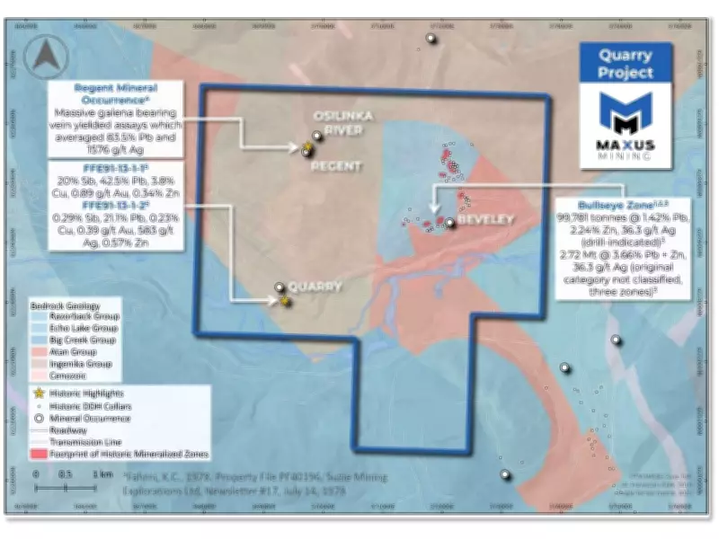
The historical estimates for the Bullseye Zone, while not compliant with current NI 43-101 standards, indicate substantial mineralization potential. These include 99,781 tonnes at 1.42% lead, 2.24% zinc, and 36.3 grams per tonne silver in a drill-indicated category, along with larger tonnage estimates of 32.72 million tonnes at 3.66% combined lead and zinc with 36.3 grams per tonne silver.
It's important to note that these historical estimates originate from Property File PF40196, specifically from a Suzie Mining Explorations Ltd. newsletter prepared by Keith C. Fahrni, P.Eng., dated July 14, 1978. The company emphasizes that these estimates are historical in nature and do not include the parameters or categories required under current CIM Definition Standards. No qualified person has completed sufficient work to classify these historical estimates as current mineral resources or reserves.
Strategic Location and Geological Setting
The Quarry project is strategically situated approximately 28 kilometers northwest of Germansen Landing in British Columbia. The property lies within favorable carbonate and dolomite breccia host rocks, geological formations known to host significant mineralization in similar mining districts throughout the region.
This location provides logistical advantages for exploration activities while being situated within a geological environment conducive to the type of polymetallic mineralization historically identified at the site. The combination of strategic location and promising historical results makes the Quarry project an attractive exploration target for Maxus Mining as the company seeks to advance the property through modern exploration techniques.

Path Forward for Resource Development
Following the completion of the historical data compilation, Maxus Mining is actively interpreting and modeling the subsurface geology and mineralization. This work aims to quickly and effectively advance the project toward modern exploration programs focused on mineral resource definition through targeted drilling.
The company's approach represents a cost-effective advancement strategy that leverages existing historical data while incorporating modern exploration technologies. By building upon decades of previous work while applying contemporary standards and methodologies, Maxus Mining aims to efficiently advance the Quarry project toward resource definition and potential development.