
Record-Low Snowpack Sparks Summer Water Concerns for B.C.'s South Coast
While skiers and snowboarders are enjoying exceptional snowfall in regions like the Kootenays, British Columbia's South Coast is experiencing a dramatically different winter scenario. The latest provincial snowpack report reveals alarming deficits that could lead to significant water challenges this summer.
Concerning Snowpack Statistics
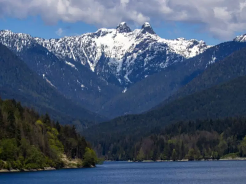
As of January 1, the South Coast snowpack stands at a staggering 67 percent below normal levels. Vancouver Island faces similarly troubling conditions with snowpack measurements 58 percent below normal. These figures contrast sharply with provincial averages, which show snowpack levels slightly above normal at 107 percent, thanks to abundant snowfall in Central and Northern B.C. regions.
Meteorologists point to several contributing factors, including unusually warm temperatures, persistent atmospheric rivers, and a dominant high-pressure ridge that has prevented typical winter precipitation patterns. "Any time we had some cooling, it was just mainly sunny or foggy in the last few days and no snow was actually reported at YVR for the last two months," noted Derek Lee, a meteorologist with Environment and Climate Change Canada.

Weather Pattern Anomalies
The current situation presents a paradox for climatologists. A weak La Niña phenomenon, which typically brings cooler temperatures and increased snowfall to the region, has failed to produce expected results. Instead, the South Coast has experienced freezing levels pushed above mountaintop elevations throughout December and January.
"There's a weak La Niña, which should produce colder temperatures and more snow, but the mild weather led to less snow and more rain," explained Michael Pidwirny, a climatologist at UBC Okanagan. Lee confirmed this assessment, noting that "the La Niña turned out to be very weak" compared to previous events that typically deliver colder conditions.
Regional Impacts and Concerns
The snowpack deficit has immediate implications for water management authorities. Peter Marshall, a hydrologist with Metro Vancouver, observed that "it's pretty warm on the mountains and it's been mostly rain on the North Shore mountains, except for maybe the highest elevations." This pattern of rain instead of snow at critical elevations reduces the natural water storage that typically sustains communities through summer months.
Regions experiencing lower-than-normal snowpack levels include:
- Lower Thompson
- Quesnel
- Lower Fraser
- South Thompson
- South Coast
- Vancouver Island
- Okanagan
Historical Context and Future Implications
The current winter season parallels the 2014-2015 period, which remains the only snowless winter on record at Vancouver International Airport. With Vancouver recording zero centimetres of snowfall this season, water managers are preparing for potential drought conditions similar to those experienced in previous low-snowpack years.
This situation creates a stark contrast within the province. While some Central and Northern B.C. regions are benefiting from above-normal snowfall after dealing with multi-year droughts, the South Coast faces increasing water security concerns. The potential for summer water restrictions looms large as authorities monitor snowpack levels and prepare contingency plans for the coming months.


