Calgary's Urban Heat Divide: Some Neighborhoods 10°C Warmer Due to Vegetation Gaps
As Calgary confronts escalating urban heat challenges, groundbreaking research has uncovered startling temperature disparities across the city's neighborhoods, with some communities experiencing summer temperatures nearly 10 degrees Celsius warmer than others. The findings highlight how gaps in urban vegetation quantity and health are creating significant thermal inequities among residential areas.
The Vegetation-Temperature Connection
Calgary-based researcher Vasylenko Yevhen has been analyzing massive public datasets to map surface temperature variations across the city. His comprehensive analysis reveals a clear and consistent pattern: neighborhoods with more concrete infrastructure—including roads, buildings, and parking lots—and less vegetation consistently register higher temperatures.
"The correlation between surface temperature and surface condition in Calgary—it's just finding gaps in community greenery," Yevhen explained. "We have huge inequity between some communities because some just don't have as many trees."

Yevhen's research, which utilizes satellite data from NASA's Landsat 8 and 9 satellites along with the European Space Agency's Sentinel-2 mission collected between June and August 2025, demonstrates that average surface temperatures can vary by close to 10°C between well-vegetated communities and heavily built-up residential areas.
Calgary's Hottest and Coolest Neighborhoods
The analysis identified specific neighborhoods experiencing the most extreme temperature variations:
- Hottest neighborhoods: Marlborough, Rundle, Penbrooke Meadows, Manchester, and Forest Lawn all recorded average surface temperatures exceeding 37.3°C during last summer
- Coolest neighborhoods: Osprey Hill, Roxboro, Discovery Ridge, Rideau Park, and Eau Claire all averaged below 30°C, with Osprey Hill registering the lowest temperature at 28.85°C
The research also reveals broader geographic patterns, indicating that western Calgary generally experiences cooler temperatures than eastern sections of the city. Extreme overheating zones appear concentrated in industrial areas and business districts.
Quality Versus Quantity of Greenery
Yevhen emphasizes that the health and quality of urban vegetation matters just as much as the quantity. Even in hotter neighborhoods like Marlborough, Manchester, and Forest Lawn that do contain urban vegetation, gaps in vegetation health are hindering cooling effects.
"We see many trees and shrubs in these communities, but with the satellite data, I see these trees don't work," Yevhen noted. "They're small and semi-dry."
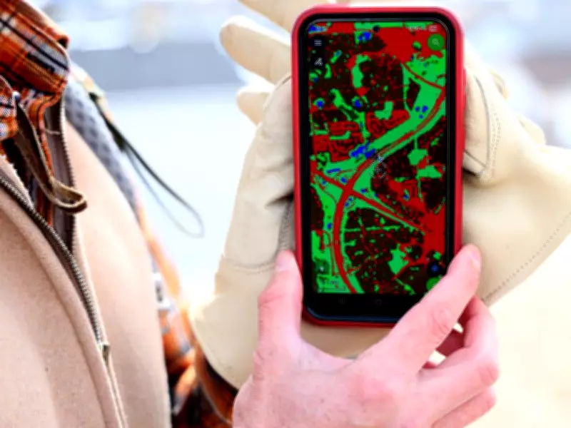
Using optical and radar data to classify land surfaces, Yevhen overlays this information on land surface temperature maps as part of his analytical approach. The Ukrainian immigrant, who arrived in Calgary in October 2022 after working as a geologist, aims to translate complex environmental data into actionable insights that can improve quality of life for Calgarians.
Broader Implications for Urban Planning
These findings align with growing global research on urban heat islands, which suggests factors including population density, landscape design, and urban planning contribute to stronger surface urban heat effects. Nature-based solutions—such as strategic tree planting and enhanced urban vegetation management—are increasingly recognized as effective tools to address urban heat challenges.
Yevhen's work represents an important bridge between massive environmental datasets and community needs, using specialized technical skills in computing to analyze information that could inform future urban planning decisions. As cities worldwide grapple with climate change impacts, understanding and addressing vegetation gaps may prove crucial for creating more equitable and livable urban environments.