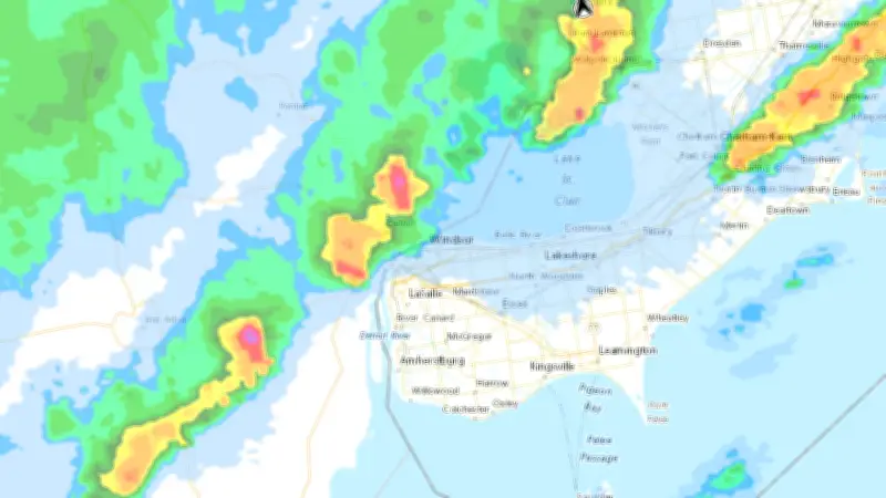
Environment Canada meteorologists are tracking a line of severe thunderstorms moving into the Windsor-Essex region, prompting warnings of hazardous travel conditions. The alert, issued on June 14, 2026, at 12:14 PM EDT, highlights the risk of heavy rain, strong winds, and potential flooding.
Key Details of the Storm
The storm system is expected to bring intense rainfall rates, gusty winds, and the possibility of localized flooding. Residents are advised to avoid non-essential travel and to stay informed about changing conditions. Environment Canada emphasizes that severe thunderstorms can produce dangerous lightning, large hail, and damaging wind gusts.
Safety Precautions
- Avoid driving through flooded roads; turn around if water covers the road.
- Stay indoors and away from windows during the storm.
- Keep emergency kits ready, including flashlights and batteries.
- Monitor local weather updates and alerts.
Impact on Transportation
Authorities warn that road conditions may deteriorate rapidly, with reduced visibility and standing water. Commuters should allow extra travel time or postpone trips until the storm passes. Public transit and highway services are on standby for potential disruptions.

Community Response
Local emergency services are prepared to respond to incidents, and residents are encouraged to report downed power lines or flooding to authorities. The storm is part of a broader weather pattern affecting southern Ontario, with more unsettled weather expected in the coming days.
Stay tuned to Environment Canada and local news for the latest updates on this developing weather event.