Edmonton Landowner Faces Potential Loss of 30 Percent of Property in Wetlands Classification Dispute
A contentious wetlands classification issue in southwest Edmonton has placed local landowner Gaurav Mann in a difficult position, with approximately thirty percent of his family's country estate now designated as protected wetland area and therefore untouchable for development. The dispute centers around conflicting assessments of how much wetland actually exists on the property, with Mann presenting scientific evidence that he believes proves a massive overestimation by initial surveys.
Conflicting Wetland Assessments Create Property Rights Dilemma
The controversy emerged during Edmonton City Council's public hearing on January 26 regarding the proposed River's Edge neighbourhood structure plan. This new community is planned for development in the southwest corner of Edmonton, situated just across the North Saskatchewan River from the existing Windemere area. Mann, whose family owns property in the affected region, voiced strong opposition during the proceedings, arguing that the wetland designation on his land has been grossly miscalculated.
"There is a wetland there, I agree—we're not opposed to any designation," Mann stated during the hearing. "But they took an area that's over 114 times what was exactly confirmed as a wetland. We are at a loss of probably hundreds of thousands of dollars, at least."

Remote Survey Versus Ground-Level Assessment
The conflict began when a remote survey conducted by engineering firm Stantec on behalf of the River's Edge developer identified 2.58 hectares of wetland on Mann's property. This assessment triggered provincial Water Act protections that require landowners to obtain permits for any activity that might impact wetland areas, including actions affecting drainage patterns, water chemistry, or local biodiversity.
Mann expressed immediate skepticism about these findings, particularly because his family had previously constructed two houses in the now-designated wetland area without encountering any regulatory issues. During public engagement sessions in 2022, Mann granted both the city and Stantec permission to conduct on-site field surveys of his property but claims he never received any follow-up communication from either party.
Independent Scientific Assessment Reveals Dramatic Discrepancy
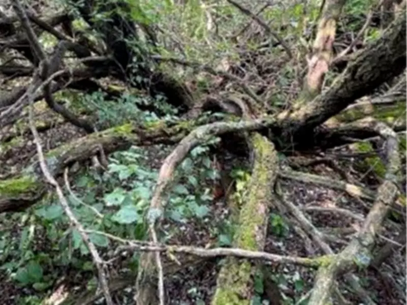
Frustrated by what he described as a "hands-off" approach from municipal authorities, Mann and his family commissioned their own independent study. They hired wetland ecologist Andrew Forrest to conduct a comprehensive, ground-level survey of the property. Forrest's detailed assessment revealed only 0.04 hectares of actual wetland—a mere fraction of the 2.58 hectares identified through remote surveying methods.
Despite this contradictory evidence, the full 2.58 hectares remains officially designated as protected wetland under current regulations. Holly Mikkelsen, a principal planner with Stantec, explained that while field investigations are required on lands belonging to development proponents, remote surveying methods are considered acceptable for non-proponent properties within the affected area.
"Detailed studies are required prior to rezoning and final land-use designation," Mikkelsen noted. "We completed the study on behalf of our client. Any individual landowners may submit their own studies and applications if they wish to pursue changes to their land-use designation."
Broader Implications for Property Rights and Urban Development
This case highlights the complex intersection of environmental protection, property rights, and urban expansion in growing municipalities like Edmonton. The provincial Water Act's wetland protections, while designed to preserve crucial ecosystems, can create significant financial burdens for landowners when assessments prove controversial or inaccurate.
The situation raises important questions about assessment methodologies, verification processes, and the rights of property owners to challenge regulatory designations that substantially impact their land value and usage options. As Edmonton continues to expand into previously undeveloped areas, similar conflicts between environmental conservation goals and private property interests may become increasingly common.

Mann's case demonstrates how technological surveying methods can sometimes produce results that diverge dramatically from ground-level observations, creating regulatory dilemmas that affect both individual landowners and broader community development plans. The resolution of this particular dispute may establish important precedents for how similar situations are handled in future Edmonton expansion projects.