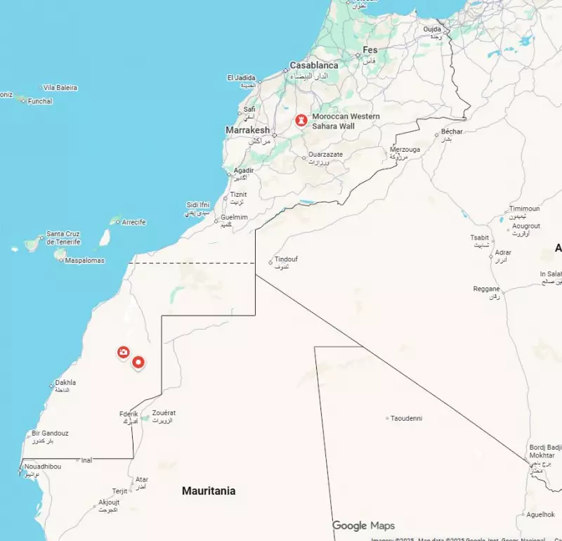
Google has officially denied allegations that it removed the border between Morocco and Western Sahara for users accessing its mapping services from within Morocco. The tech giant responded to growing concerns about potential digital cartography manipulation in geopolitically sensitive regions.
The Border Dispute Controversy
The controversy emerged when users reported discrepancies in how Google Maps displayed the contested Western Sahara territory. Some observers claimed that the border demarcation appeared differently depending on whether users accessed the service from Morocco or other locations. This sparked concerns about the company potentially bowing to political pressure in regional disputes.
Western Sahara remains one of Africa's most contentious territorial issues, with Morocco claiming sovereignty over the entire territory while the Polisario Front seeks independence. The region's status has been disputed since Spain withdrew in 1975, creating a complex geopolitical landscape that continues to challenge international relations and corporate policies.
Google's Official Response
In a statement addressing the allegations, Google representatives firmly denied making any special accommodations for Moroccan users. The company emphasized its commitment to maintaining consistent mapping data across all regions and user locations. Google officials explained that their mapping services aim to reflect current international consensus and United Nations positions on border disputes.
The technology company faces ongoing challenges in navigating politically sensitive border regions worldwide. From the South China Sea to Kashmir and now Western Sahara, digital mapping platforms increasingly find themselves at the center of international disputes. Google maintains that it relies on recognized international boundaries and consults with relevant authorities and international organizations when making cartographic decisions.
Broader Implications for Digital Mapping
This incident highlights the growing significance of digital mapping in international politics and territorial claims. As mapping technologies become more sophisticated and widely accessible, their role in shaping perceptions of borders and sovereignty continues to expand. Technology companies face increasing pressure from governments, advocacy groups, and users to take positions on contentious geopolitical issues through their mapping representations.
The Western Sahara mapping controversy comes amid broader discussions about how tech giants handle sensitive political content. Similar debates have emerged around how platforms label regions like Crimea, Taiwan, and Palestine. These cases demonstrate the complex intersection of technology, politics, and international relations in the digital age.
Google's denial of altering maps for specific user groups reinforces the company's stated policy of maintaining neutral, consistent mapping data. However, the incident underscores the ongoing challenges digital platforms face in balancing accuracy, consistency, and political sensitivity across diverse global markets and contested territories.


