

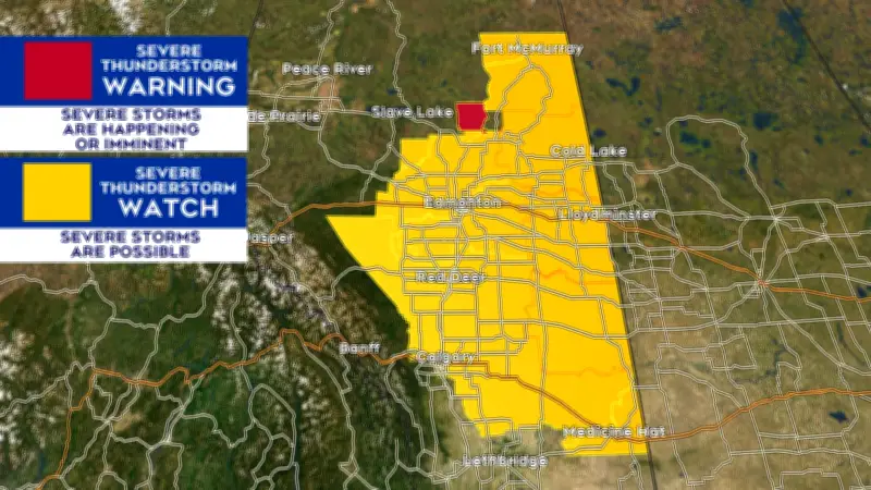
A severe thunderstorm watch has been issued for many parts of Alberta on July 8, 2026, according to Environment Canada. The watch covers a broad swath of the province, including Edmonton, Calgary, and surrounding areas, with conditions favourable for the development of dangerous storms capable of producing large hail, damaging winds, and heavy rainfall.
Timing and Affected Regions
The watch came into effect early Thursday afternoon and is expected to last into the evening hours. Meteorologists warn that storms could develop rapidly, bringing gusts up to 90 km/h and hail the size of quarters or larger. Regions from the U.S. border north to Edmonton and west to the Rocky Mountain foothills are under the watch.
Potential Impacts
Residents are advised to secure loose objects, avoid parking under trees, and stay indoors during storms. Heavy downpours could lead to localized flooding, especially in low-lying areas and urban centres with poor drainage. Power outages are possible due to high winds and lightning strikes.

According to Josh Classen of CTV News Edmonton, “The setup today is classic for Alberta severe thunderstorms: a cold front moving in from the west colliding with warm, moist air from the south. This creates an unstable atmosphere perfect for storm development.”
Safety Precautions
Environment Canada urges the public to monitor alerts and take shelter immediately if a warning is issued. Severe thunderstorm warnings are more urgent than watches and indicate that a storm is imminent or occurring.
This marks the first significant thunderstorm threat of the summer season for the province, following a dry June that left many farmers hoping for rain but wary of destructive storms. The watch is expected to remain in effect until late Thursday night.