
London's Weather Swings: Warm Stormy Thursday Leads to Sharp Temperature Plunge
Residents of London, Ontario, experienced a dramatic meteorological rollercoaster this week, as a notably warm and stormy Thursday abruptly transitioned into a sharp and significant temperature drop. The sudden shift has left many reaching for heavier coats and adjusting weekend plans, highlighting the region's unpredictable spring weather patterns.
A Day of Contrasts: From Warmth to Chill
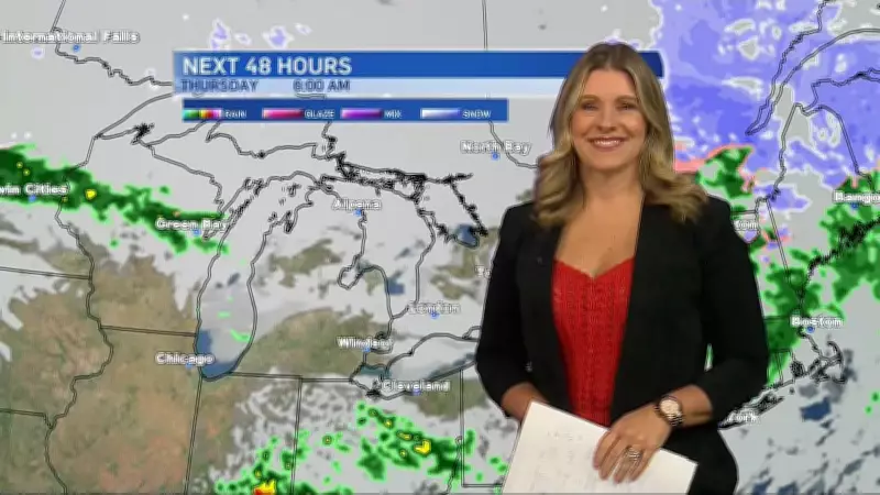
Thursday unfolded with unseasonably warm temperatures, accompanied by showers, gusty winds, and the potential for thunderstorms across the Windsor-Essex and broader London areas. This period of atmospheric instability was marked by humid conditions and sporadic heavy rainfall, creating a stark contrast to the cooler norms typically expected in late March.
However, the warmth was short-lived. By late Thursday and into Friday, a powerful cold front swept through Southern Ontario, ushering in a pronounced cooldown. Temperatures plummeted, dropping by as much as 10 to 15 degrees Celsius in some locales, returning values to seasonal or even below-seasonal averages. This rapid decline serves as a potent reminder of spring's transitional nature, where winter's grip can reassert itself without warning.

Meteorological Insights and Broader Forecast
CTV London Meteorologist Julie Atchison provided detailed analysis, noting that such sharp contrasts are not uncommon during seasonal shifts. The clash of warm, moist air from the south with colder, drier air masses from the north often triggers these volatile conditions, she explained. The stormy activity on Thursday was a direct result of this atmospheric battle.
Looking ahead, the forecast suggests continued variability. While the immediate plunge brings cooler, clearer conditions, the potential for further precipitation and temperature swings remains high for the weekend and into next week. Residents are advised to stay updated with local forecasts, as the pattern may bring additional rain showers or even a late-season wintry mix in elevated areas.
Regional Context and Safety Reminders
This weather event occurs amidst other notable regional stories, from political debates on education policy to infrastructure developments. Yet, the immediate impact of the temperature drop is felt locally, affecting commutes, outdoor activities, and energy usage.
Authorities remind the public to exercise caution during such rapid changes. Gusty winds accompanying the front could lead to isolated power outages or minor property damage. Drivers should be prepared for potentially slick roads from residual moisture and changing visibility conditions. As always, staying informed through reliable weather sources is the best defense against nature's unpredictability.


