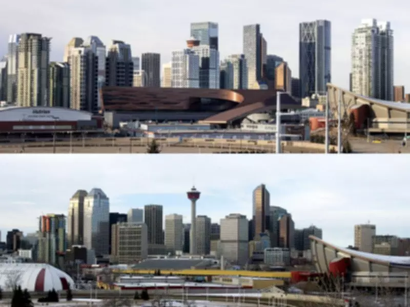
Calgary's Skyline Transformation: A 20-Year Photographic Comparison
When tasked with documenting Calgary's growth toward two million residents, a Postmedia photographer embarked on a unique mission: to recreate a 2006 skyline photograph exactly twenty years later. The original image, captured by late Calgary Herald photographer Ted Rhodes on January 31, 2006, served as both inspiration and blueprint for this urban comparison project.
The Original Photograph and Its Creator
Ted Rhodes' photograph, taken from Scotsman's Hill in the Ramsay neighborhood, showcased Calgary's downtown skyline at a pivotal moment—the year the city reached one million residents. Rhodes, who joined the Calgary Herald in 2003 and retired in 2016, tragically died in a skiing accident at Fernie on February 12, 2022. His 2006 image became the foundation for this photographic time capsule.
The Technical Challenge of Replication
Armed with modern technology and determination, the photographer used Google Earth to meticulously align the 3D-rendered buildings with Rhodes' original composition. "I tilted the viewer horizontal and sat lining up the 3D-rendered buildings," the photographer explained, noting that many structures visible in 2006 were now obscured by newer developments.

The process involved careful positioning on Scotsman's Hill's broad ridge, aligning landmarks like the Saddledome and Calgary Stampede chuckwagon track. Technical analysis suggested Rhodes likely used a longer focal length rather than a wide-angle lens, given how buildings appeared stacked in the original image.
Dramatic Urban Changes Revealed
The comparison reveals striking transformations in Calgary's urban landscape. The recently expanded BMO Centre now dominates the foreground, while numerous new skyscrapers have reshaped the skyline, nearly obscuring the iconic Calgary Tower that once stood prominently at the city's center.
Key changes documented include:
- The Vetro condominium tower, under construction in 2006, now completed
- Multiple glass obelisks that have transformed the downtown core
- The expanded BMO Centre positioned prominently in the frame
- Older buildings now partially or completely hidden behind newer structures
Overcoming Obstacles and Finding Access
The photographic mission faced unexpected challenges, including a chain-link fence at the escarpment's edge marking Stampede storage lots. Just as hope for the perfect angle seemed lost, a chance encounter with a local resident provided access to a private backyard offering the ideal vantage point.
"As we wound our way through the back garden of the property, I again wondered whether Rhodes had done something similar," the photographer reflected, considering whether the original image might have been captured through similar community cooperation.
A Visual Record of Urban Evolution
This photographic project serves as more than just technical exercise—it provides a tangible visual record of Calgary's rapid urban development over two decades. The side-by-side comparison offers residents and urban planners alike a powerful perspective on how infrastructure, architecture, and city planning have reshaped the metropolitan landscape.
The images tell a story of growth, change, and continuity, capturing both the physical transformation of buildings and the enduring spirit of community that makes such photographic documentation possible.