Vancouver-based Maxus Mining Inc. (CSE: MAXM | FRA: R7V) has released significant highlights from a historical data compilation at its Quarry Project, located in the mineral-rich Bralorne Mining District of British Columbia. The announcement, made on January 6, 2026, follows the company's recent consolidation of the property through the acquisition of the Beveley Property in late September 2025.
Historic Drill Results Reveal Promising Grades
The company's comprehensive review of historical assessment reports has brought to light several high-grade intercepts from past drilling campaigns. The compiled data, which informed a reconnaissance field program conducted by Palliser Exploration in fall 2025, includes notable drill hole results such as 23.6 metres averaging 1.83% lead, 2.82% zinc, and 56.2 grams per tonne silver. Another hole intersected 16.91 metres grading 2.42% lead, 2.43% zinc, and 87.7 g/t silver.
These findings are part of a broader historical dataset that outlines multiple zones of base and precious metal mineralization across the property, providing a solid foundation for Maxus's modern exploration strategy.

Historical Estimates and High-Grade Surface Samples
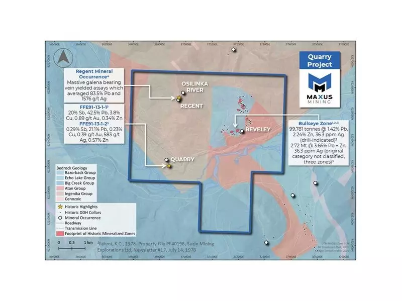
Beyond drilling, the historical work points to substantial mineralized potential. A historical, non-NI 43-101 compliant estimate for the Bullseye Zone cited a drill-indicated resource of 99,781 tonnes at 1.42% lead, 2.24% zinc, and 36.3 g/t silver. A separate historical block estimate, with unclassified categories and unknown parameters, suggested a larger tonnage of 2.72 million tonnes.
Perhaps even more striking are the results from historic grab sampling. Samples from a massive galena-bearing vein system at the Regent occurrence returned an average assay of 83.5% lead and 1,576 g/t silver. Additional samples reported exceptionally high values, including 20% antimony, 42.5% lead, 3.8% copper, and 0.89 g/t gold, underscoring the polymetallic nature of the mineralization.
Path Forward for the Quarry Project
Scott Walters, Chief Executive Officer of Maxus, emphasized the value of this historical body of work. "Historic exploration at the Project has generated a meaningful body of sampling, drilling, and mapping data that documents polymetallic mineralization across the Property," Walters stated. "This body of historical information provides important context for the mineralized zones identified to date and informs the Company’s ongoing review of the Project."
The company is now focused on a cost-effective advancement strategy. This involves compiling all historical drillhole data into 2D and 3D models to better interpret the subsurface geology and mineralization. The goal is to efficiently guide the project toward new, modern exploration and drilling programs. The results from the 2025 field program are currently pending.
Strategically situated approximately 28 kilometres northwest of Germansen Landing, British Columbia, the Quarry Project lies within favourable carbonate and dolomite breccia host rocks, a setting known for hosting significant mineral deposits.