Greenridge Exploration Announces Completion of Advanced 3D Geological Modelling Program
VANCOUVER, British Columbia – Greenridge Exploration Inc. has reached a significant milestone in its exploration efforts with the successful completion of an integrated 3D multi-physics inversion and machine-learning-assisted lithology modelling program at its Carpenter Lake Uranium Project. The project is strategically positioned along the Cable Bay Shear Zone on the southern margin of the Athabasca Basin in northern Saskatchewan, one of the world's most prolific uranium-producing regions.
Advanced Technology Integration for Enhanced Exploration
The comprehensive program was executed through a collaboration between Convolutions Geoscience Corp. and Computational Geosciences Inc., who served as independent inversion specialists. The work utilized the innovative Geophysics-Informed Lithology Interpolation platform, representing a sophisticated approach to geological interpretation that combines multiple data sources with advanced computational methods.
Russell Starr, CEO of Greenridge Exploration, emphasized the significance of this technological advancement: "The collaboration with Convolutions and CGI has enabled us to produce a detailed 3D model of the Carpenter Lake geology, demonstrating our commitment to adopting cutting-edge exploration technology. The Cable Bay Shear Zone represents a complex and highly prospective structure for uranium mineralization, and these joint inversions along with the resulting GILI model will significantly enhance our future drill targeting across more than 15 kilometers of strike length."

Comprehensive Data Integration and Analysis
The modeling program represents the first fully integrated reinterpretation of the project's historical airborne datasets, incorporating:
- 2014 versatile time-domain electromagnetic survey data
- 2015 Falcon Airborne Gravity Gradiometry survey capturing all seven tensor components
- High-resolution Total Magnetic Intensity data
The technical teams applied a modern inversion workflow that included:
- Parametric plate modelling of VTEM conductors
- Cross-gradient joint inversion of gravity and electromagnetic datasets
- 3D lithology model generation using the GILI platform
- Implementation of high-resolution OcTree and tensor meshes
- Incorporation of Greenridge's 2025 drilling data along with physical property and structural measurements from drill core
Technical Breakthroughs and Structural Interpretation
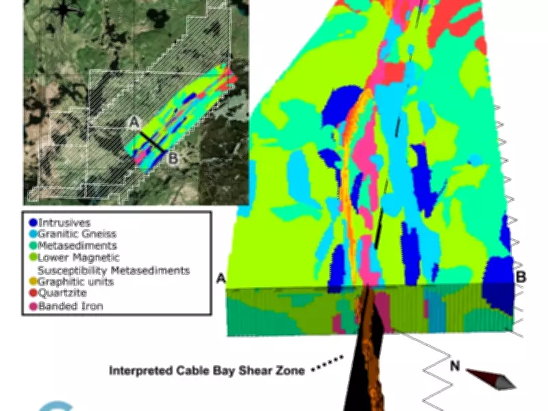
This integrated approach has produced comprehensive 3D physical property models that are consistent with all available data, along with a detailed lithology model of the Cable Bay Shear Zone corridor. The work represents a substantial advancement in the structural interpretation of the project area, providing unprecedented insights into the geological framework.
Initial unconstrained VTEM inversions had previously struggled to fully resolve the steep, shear-hosted conductors identified through drilling and mapping activities. The application of parametric plate inversions by CGI successfully modelled the Cable Bay Shear Zone as a series of steeply dipping rectangular conductive bodies, overcoming previous technical limitations.
The resulting 3D lithology model highlights the Cable Bay Shear Zone and its closely associated graphitic pelite horizons, providing both isometric and plan-view perspectives of the geological structures within the project boundaries. This detailed visualization represents a significant step forward in understanding the complex geology of this prospective uranium exploration area.