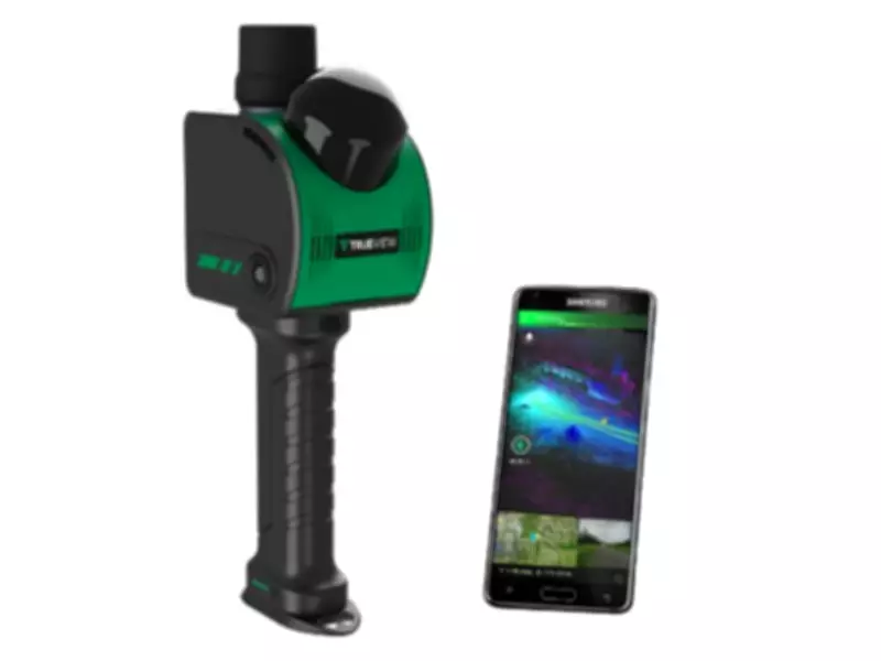
GeoCue Introduces TrueView GO NEO Handheld LiDAR Scanner at Geo Week 2026
GeoCue, a prominent leader in geospatial hardware and point cloud processing software, has announced the upcoming release of the TrueView GO NEO, a new handheld SLAM LiDAR system that expands the company's TrueView handheld LiDAR product lineup. Unveiled at Geo Week 2026 in Denver, Colorado, the TrueView GO NEO is designed to provide a smaller, lighter, and more portable option for handheld mapping, making it easier, more flexible, and more affordable, particularly for indoor capture applications.
Enhanced Portability and Performance
The TrueView GO NEO completes the range of GeoCue's handheld systems by offering a rugged, no-moving-parts design that delivers serious performance for teams requiring dense data and dependable SLAM in challenging environments such as corridors, stairwells, and mechanical rooms. For added simplicity in the field, the TrueView GO NEO conveniently pairs with smartphones, keeping workflows streamlined and the total cost of ownership low.
Since introducing the original TrueView GO 116S and TrueView GO 132S handheld systems, GeoCue has witnessed rapid adoption of handheld mapping workflows across various sectors including surveying, construction, public safety, and facility documentation. The new TrueView GO NEO extends this momentum with enhanced capabilities tailored for indoor and feature-poor mapping scenarios.

Advanced Technology for Indoor Mapping
At the core of the TrueView GO NEO is a new high-rate scanning engine capable of capturing up to 1.15 million points per second, delivering dense detail while improving field efficiency. An ultra-wide field of view (360° × 189°) increases coverage overhead and helps reduce missed areas, allowing users to capture complete scenes faster without needing to scan every surface meticulously.
The NEO also introduces Deep INS + SLAM Fusion, which pairs SLAM mapping with a high-grade inertial navigation system to improve stability in feature-poor environments where typical consumer-grade navigation systems might struggle. This results in more reliable trajectories and improved point cloud integrity in challenging scenarios such as long corridors and multi-floor stairwells, where drift and misalignment can otherwise degrade results.
Enhanced Visualization and Deliverables
To enhance interpretation and deliverables, the TrueView GO NEO includes HD colorization and advanced image capture designed to support panoramic imagery and detailed colorization even in low-light environments. Users can leverage these images to create visual outputs such as mesh models and high-fidelity reality renderings for downstream documentation and visualization workflows.
Complete Workflow Integration with LP360 Land
TrueView GO NEO is paired with LP360 Land, GeoCue's purpose-built software for handheld LiDAR processing, quality assurance, quality control, visualization, and deliverable creation. LP360 Land enables users to generate detailed point clouds from raw data, validate coverage and quality, and produce outputs aligned to real project workflows without adding unnecessary complexity.
Frank Darmayan, CEO of GeoCue, commented on the launch, stating, "We've seen exceptional growth in the handheld LiDAR market since the launch of our original TrueView GO 116S and 132S. By expanding our offering with the new TrueView GO NEO, we're giving customers a simple way to adapt to handheld LiDAR, and bringing to market a scanner that delivers greater efficiency and performance, especially for indoor data capture, at a very affordable price."
The TrueView GO NEO represents a significant advancement in handheld LiDAR technology, offering a comprehensive, end-to-end workflow solution for professionals in geospatial and mapping industries. With its focus on indoor capture and enhanced performance features, it is poised to meet the growing demands for efficient and reliable reality capture in complex environments.