Stallion Uranium Corp. has intersected elevated radioactivity exceeding 300 counts per second in all three initial drill holes at its Coyote target, part of the Moonlite project in the Southwest Athabasca Basin, Saskatchewan. The company, in partnership with Atha Energy Corp., has expanded its Phase 1 drill program from 4,000 to 5,500 metres and mobilized a high-resolution ground Time Domain Electromagnetic (TDEM) survey along the Coyote target corridor.
Drilling Progress and Results
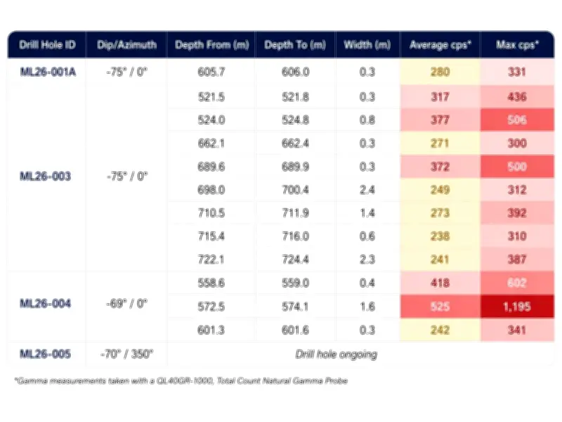
As of June 30, 2026, approximately 3,527 metres of drilling have been completed, with operations continuing as planned. The first three holes on the main Coyote target all intersected elevated radioactivity (>300 cps), along with substantial hydrothermal alteration and strong structural features within the sandstone and underlying basement rocks.
Darren Slugoski, Vice President of Exploration, stated, “Encountering consistent alteration and structural complexity across every drill hole is a strong positive signal in the Athabasca Basin. We’re seeing the classic signatures of uranium systems; sandstone bleaching, clay alteration, brecciation, and faulting, which frequently act as conduits and depositional sites for uranium fluids. These real-time observations are sharpening our targeting as the program advances.”

Geophysical Model Validation
The discovery of a graphitic fault zone alongside pronounced structural complexity and alteration validates the company’s integrated geophysical model. These findings highlight a structurally active and hydrothermally altered corridor at Coyote, consistent with a fertile uranium system. The intersections confirm the presence of a well-developed hydrothermal system, underscoring the potential for uranium deposition.
Expanded TDEM Survey
Stallion has mobilized an expanded high-resolution Stepwise Moving Loop (SWML) TDEM survey to sharpen and extend prior electromagnetic data. The survey aims to delineate conductive features typically linked to uranium deposits. Abitibi Geophysics has been contracted to complete the survey over three 3.2 km-long lines using seven transmitter loops (each 400 m x 600 m) with overlapping measurements. The survey will employ Abitibi’s proprietary ARMIT-TDEM system, which captures both B-field and dB/dt responses across three components simultaneously, enhancing the detection and resolution of subsurface conductors.