Toronto Endures Historic Snowfall as Winter Storm Sets New Single-Day Record
A massive winter storm has delivered a historic blow to Toronto, officially setting a new single-day snowfall record for the city. The intense system, which moved through the region on Sunday, January 25, 2026, dumped unprecedented amounts of snow, surpassing all previous benchmarks for a 24-hour period.
Unprecedented Snowfall Rates and Immediate Impacts
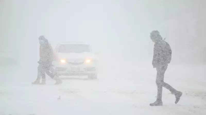
Environment Canada had warned residents of peak snowfall rates reaching an astonishing five to eight centimetres per hour as the storm intensified. This led to rapid accumulation that blanketed the city, transforming streets and sidewalks into challenging winter landscapes. The sheer volume of snow has caused significant disruptions across the Greater Toronto and Hamilton Area (GTHA).
Public transit systems are facing major operational challenges, with delays and cancellations affecting commuters. The Toronto Transit Commission and other regional services are struggling to maintain schedules as crews work tirelessly to clear tracks and roads. Similarly, air travel has been heavily impacted, with flight schedules at Toronto Pearson International Airport and even connecting airports like Vancouver experiencing numerous cancellations and delays due to the blizzard conditions.

Widespread Closures and Community Response
In response to the severe weather, numerous school boards across the GTHA have announced closures for Monday, prioritizing student safety. This follows a pattern of storm-related shutdowns that have become necessary to manage the extreme conditions. While some regions, like Ottawa, have reported school buses running, many eastern Ontario and Renfrew County services have been cancelled.
Local authorities are urging residents to exercise caution, advising people to avoid unnecessary travel and to check on vulnerable neighbours. The Canadian Automobile Association (CAA) has reported a surge in service calls, particularly related to car battery failures in the frigid temperatures, anticipating one of their busiest days of the year.
Broader Weather Context and Safety Reminders
This record-setting event in Toronto is part of a larger severe weather pattern affecting much of Canada. Ontario, Quebec, and the Maritime provinces are bracing for dangerously low temperatures, with wind chills potentially dipping near -50°C in the coming weekend. Such conditions heighten risks like frostbite and hypothermia, making preparedness essential.
Officials also remind citizens to keep fire hydrants clear of snow to ensure emergency access and to maintain working smoke alarms, especially as heating demands increase. The storm serves as a stark reminder of winter's power in urban centres, testing infrastructure and community resilience alike.
As Toronto digs out from this historic snowfall, meteorologists continue to monitor the evolving weather systems, while city crews and residents alike confront the monumental task of recovery and adaptation in the face of an unforgettable winter wallop.