
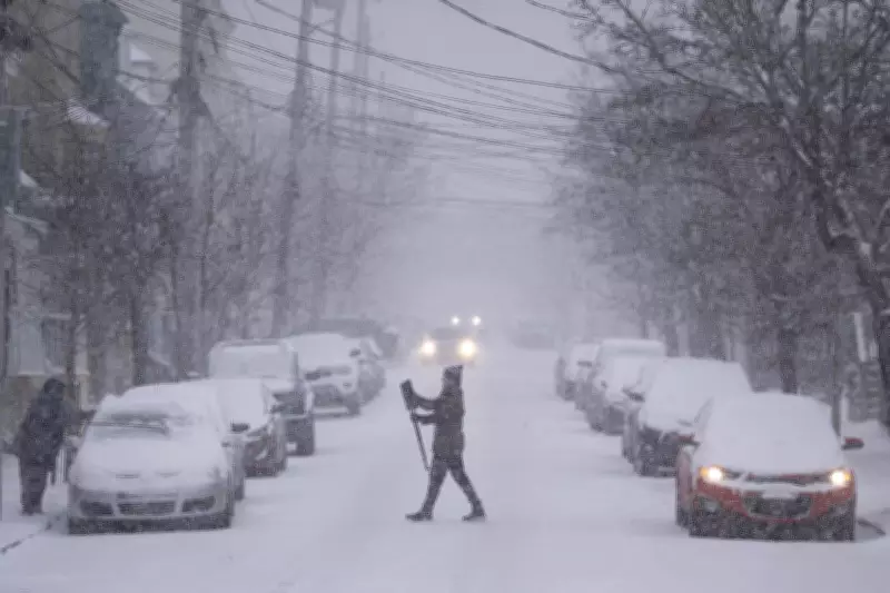
A powerful late-season winter storm is poised to strike Atlantic Canada, bringing a significant blast of winter weather to Nova Scotia and Newfoundland and Labrador. This system is expected to deliver heavy snowfall accumulations and potentially damaging wind gusts, creating hazardous conditions across the region.
Impending Weather System Details
Meteorological models indicate that a low-pressure system developing off the coast will intensify rapidly as it approaches the Maritimes. This storm's timing is notable for occurring well into the spring season, serving as a reminder that winter conditions can persist in eastern Canada. Residents should prepare for reduced visibility on roads and possible transportation disruptions.
Expected Impacts on Nova Scotia
The province of Nova Scotia is forecast to receive substantial snowfall, particularly across northern and central regions. Coastal areas may experience a mix of precipitation types, including rain and ice pellets, before transitioning to snow as temperatures drop. Halifax and surrounding communities should anticipate challenging commuting conditions, with potential school closures and flight cancellations at the international airport.

Forecast for Newfoundland and Labrador
Newfoundland and Labrador will face similar winter weather challenges, with the storm system expected to strengthen as it moves northeastward. The Avalon Peninsula and eastern Newfoundland could see the heaviest snowfall rates, accompanied by strong easterly winds that may cause blowing snow and localized whiteout conditions. Residents are advised to secure outdoor items and prepare for possible power outages.
Safety Recommendations and Preparedness
Local authorities are urging residents to take necessary precautions ahead of the storm's arrival. Emergency management officials recommend:
- Stocking emergency kits with essential supplies for at least 72 hours
- Avoiding non-essential travel once conditions deteriorate
- Checking on vulnerable neighbors, particularly seniors and those with limited mobility
- Ensuring heating systems are functioning properly as temperatures will drop significantly
Transportation departments have prepositioned snow-clearing equipment and are prepared to deploy crews as needed. Motorists are reminded to adjust driving speeds for winter conditions and maintain increased following distances between vehicles.
Historical Context and Climate Patterns
This late-season storm follows a pattern of variable spring weather that Atlantic Canada frequently experiences. While average temperatures typically rise during March, cold air masses from the Arctic can still collide with moisture-laden systems from the south, creating significant winter weather events. Climate researchers note that such late-season storms may become more variable in timing and intensity as global climate patterns continue to evolve.
Environment Canada will issue updated watches and warnings as the storm system develops and its track becomes more certain. Residents should monitor official forecasts through reliable sources and prepare for potentially rapidly changing conditions throughout the storm's duration.


