
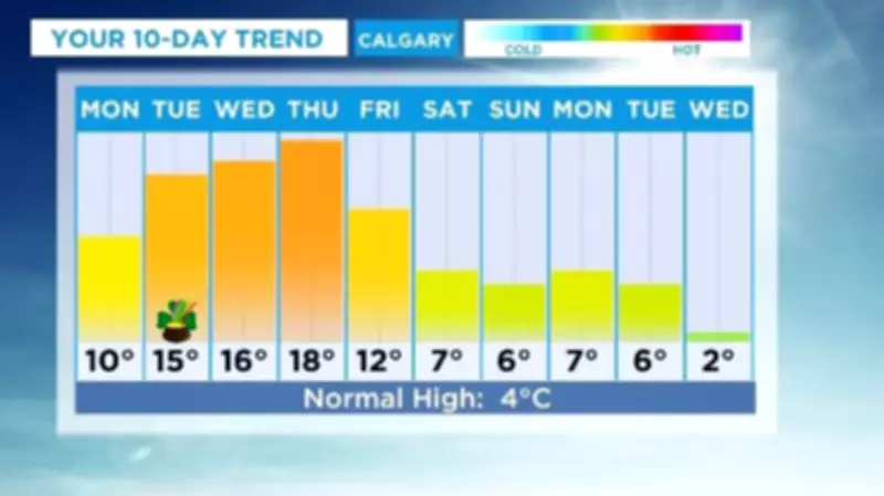
Residents of Calgary are bracing for a week of significant weather contrasts, beginning with hazardous conditions before a rapid warm-up. The city is set to experience wet and icy surfaces to start the week, posing challenges for commuters and pedestrians alike. However, a dramatic shift is on the horizon, with temperatures expected to soar to a high close to 20 degrees Celsius by Thursday.
Early Week Hazards and Warnings
Environment Canada has issued warnings for strong winds through Tuesday morning, adding to the treacherous conditions. These winds could exacerbate the icy surfaces, making travel particularly difficult. The agency advises caution, especially during the early part of the week when the risk of slips and falls is heightened.
Temperature Swing and Atmospheric Influences
The forecast highlights a stark transition from cold to unseasonably warm weather. This shift is part of a broader pattern affecting Western Canada, including an approaching atmospheric river that is bringing wet and windy conditions to parts of British Columbia. While Calgary may not see the full brunt of this system, it contributes to the unstable weather patterns.

By mid-week, temperatures are projected to climb steadily, reaching near 20°C by Thursday. This rapid warming could lead to melting ice and potential flooding in low-lying areas, so residents should stay informed about local advisories.
Broader Regional Context
This weather event is not isolated to Calgary. Other regions, such as the Sea to Sky Highway in B.C., are under winter storm warnings due to a prolonged atmospheric river. Meanwhile, parts of the Maritimes are facing heavy rain and high winds. These systems illustrate the dynamic and often extreme nature of Canadian weather in early spring.
As the week progresses, Calgarians should prepare for a rollercoaster of conditions—from icy starts to balmy afternoons. Staying updated with the latest forecasts from Environment Canada is crucial for safety and planning.


