VANCOUVER, British Columbia – Maxus Mining Inc. (CSE: MAXM | OTCQB: MXMGF | FRA: R7V) has announced the completion of an advanced geophysical interpretation by Convolutions Geoscience Corporation on the airborne Mobile Magnetotelluric survey at its 100%-owned Penny Project. The interpretation outlines multiple conductive and structural target areas, including features spatially associated with the Palmer Bar Fault corridor and related cross-cutting structures, as well as known copper occurrences.
Geophysical Interpretation Highlights
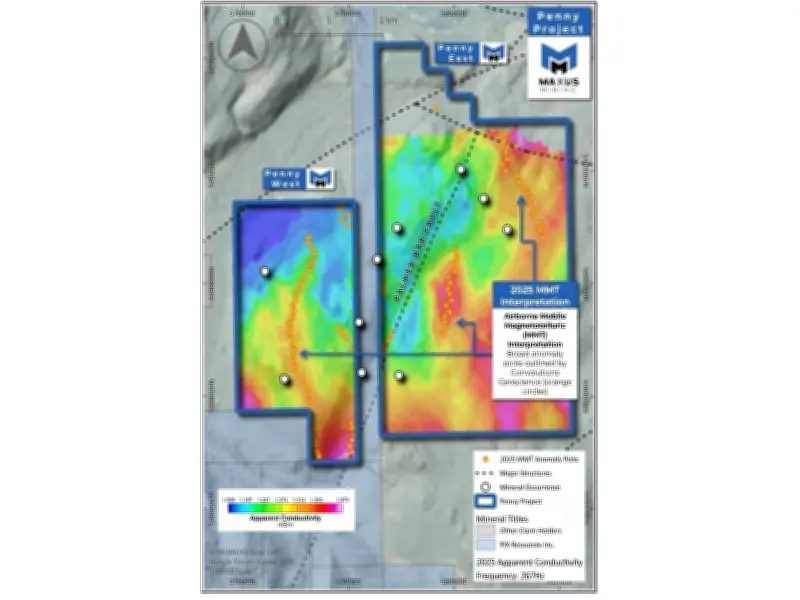
Convolutions completed the interpretation of the 2025 airborne MobileMT survey, which comprised approximately 519 line-kilometres over a 46 km² area. The survey was designed to map bedrock structure, lithology, conductivity, and resistivity features. The interpretation identified multiple conductive trends and structural target areas, including features associated with the Palmer Bar Fault corridor. Conductive horizons are interpreted to potentially reflect sulphide- or graphite-bearing stratigraphy within the Creston Formation, though further work is required to determine the source of conductivity.
Maxus intends to integrate the interpretation with recent geological mapping, soil and rock geochemistry, and historical exploration datasets to prioritize follow-up exploration targets at the Penny Project.

CEO Commentary
Scott Walters, Chief Executive Officer of Maxus, commented: “The interpretation completed by Convolutions Geoscience has significantly advanced our understanding of the Penny Project and highlighted multiple priority target areas for follow-up exploration. The strong correlation between interpreted conductive trends, major structural corridors, and known copper-silver occurrences significantly increases our confidence in the project’s potential. We believe Penny represents an exciting exploration opportunity within the prolific Belt-Purcell Basin.”
About the Penny Project
The Penny Project consists of approximately 3,123 hectares situated within the Belt-Purcell Basin of southeastern British Columbia, 17 kilometres southeast of the historic Sullivan Mine at Kimberley. The project hosts numerous historical mineral occurrences and benefits from over a century of recorded exploration activity.
Historical and recent exploration work at Penny has included geological mapping, prospecting, geophysics, and rock sampling programs targeting copper-rich mineralization associated with favourable regional structures and alteration systems. Historical work identified multiple copper-silver showings, including the Penny Man occurrences, where mineralization is commonly associated with faults, shears, silicification, and fracture-controlled sulphides.
Prior to Maxus’ acquisition, historical sampling returned copper values including 1,046 ppm Cu, 1,808 ppm Cu, and 2,388 ppm Cu. Since acquiring the project, Maxus completed a high-resolution airborne MobileMT survey followed by geological mapping and surface sampling, with surface rock samples returning values up to 0.34% Cu.